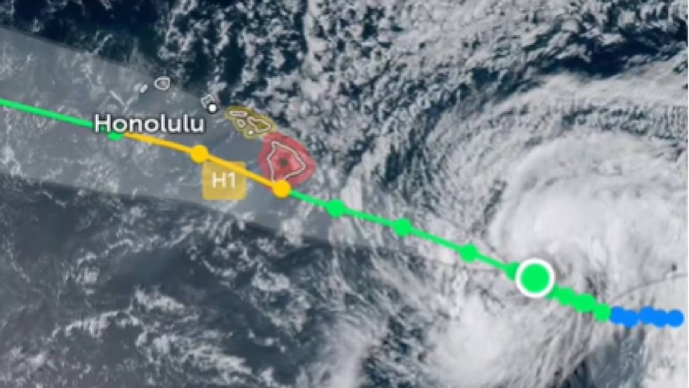
Miami (USA).- Tropical Storm Lala became a category 1 hurricane this Saturday, the third of the season in the Pacific, and is heading towards Hawaii with maximum sustained winds of up to 120 kilometers per hour.
The hurricane is located less than 120 kilometers southeast of the southernmost point of the archipelago and is moving at 15 kilometers per hour, according to the latest bulletin from the United States National Hurricane Center (NHC).
You may be interested in: Tropical Storm Cristobal forms in the Atlantic
The agency forecasts that it will pass very close to the main island of Hawaii, which would make Lala the first hurricane to make landfall in the archipelago since 1992.
Active warnings and areas at risk
The NHC issued a hurricane warning for Hawaii County (Big Island) and a tropical storm watch for Maui County, which includes the islands of Maui, Lanai, Molokai and Kahoolawe, reported The Associated Press.

The Hawaii Emergency Management Agency (HIEMA) details an island-by-island progression sequence: impacts on the Big Island would begin Friday night; by Saturday morning they would reach Maui Nui; by the afternoon and evening they would arrive on Oʻahu, and by Saturday night they would affect Kauaʻi. The effects of rain, wind, and surf could extend through Sunday across the entire archipelago.
Oʻahu is not under a hurricane or tropical storm watch as of this writing, but the Honolulu Mayor’s Office warns that “dangerous conditions can extend far from the center of a tropical cyclone”.
Historic rainfall and risk of deadly flooding
The projected rainfall figures are what concern meteorologists the most. The NHC estimates accumulations of between 8 and 12 inches (20 to 30 centimeters) on Maui and the Big Island, with local peaks of up to 25 inches (almost 64 centimeters) in mountainous areas of the Big Island. That volume of water can trigger life-threatening flash floods and landslides, according to the forecast center.


HIEMA adds to that outlook a storm surge of up to 3 feet (just under a meter) on south-facing shores, along with destructive winds exceeding 74 mph (119 km/h) in some areas and dangerous rip currents statewide.
Before the tropical moisture arrives, strong winds are expected on Friday with dry conditions that increase the risk of wildfires. The Honolulu Mayor’s Office asks residents to avoid any activity that could generate sparks and to report any sign of fire or smoke immediately.
Emergency operations in Honolulu
The City and County of Honolulu activated its Emergency Operations Center (EOC) and the Honolulu Police Joint Operations Center (JOC) starting at 7 a.m. Friday. Both facilities bring together municipal departments, first responder agencies, and emergency management personnel to coordinate the deployment of resources during the storm.
Mayor Rick Blangiardi urged residents not to wait for a formal alert to be issued: “We have spent this week preparing our city for this storm, and I want everyone on Oʻahu to use the time we have left to make sure they are ready.”
Honolulu Emergency Medical Services (EMS) anticipates an increase in 911 calls over the weekend and is asking the public to avoid unnecessary travel to keep roads clear for emergency vehicles.
The Ocean Safety Department reinforced patrols on the south and east shores of Oʻahu, with extended coverage until 7:30 p.m.

What residents should do now
HIEMA and the Honolulu Mayor’s Office agree on a series of priority actions for those who have not yet taken action:
- Secure outdoor furniture and any loose objects that the wind could turn into projectiles.
- Cover windows and glass doors, and seal gaps to prevent rain and wind from entering.
- Remove dead, damaged, or hanging branches that could fall on the house.
- Clean gutters and drains to reduce the risk of flooding.
- Elevate valuables above ground level.
- Gather medications, water, food, a radio, and backup batteries for several days.
- Charge phones, portable batteries, and medical equipment before the storm arrives.
Residents in flood-prone areas, near streams, or along the coastline should monitor conditions closely and be ready to act if authorities indicate so. Never cross a flooded road or fast-moving water, warns HIEMA.