Santo Domingo. – The Dominican Republic’s Meteorology Institute (INDOMET) warned of the indirect impact of a trough that will cause some in the Dominican Republic, especially in municipalities of the provinces; Hato Mayor, Sánchez Ramírez, San Cristóbal, as well as Greater Santo Domingo, Monseñor Nouel, San Juan, Elías Piña, Monte Cristi, Monte Plata, Santiago, Santiago Rodríguez, Valverde and Dajabón among other nearby ones.
However, for tomorrow Tuesday; from the early hours of the day, the humidity caused by the change of wind direction east/northeast and the indirect incidence of an upper-level trough, in addition to local effects, will cause cloud cover increases generating scattered showers, isolated thunderstorms and wind gusts, mainly over different locations in La Altagracia, El Seibo, Hato Mayor, Monte Plata, La Romana, San Pedro de Macorís, San Cristóbal, Samaná, María Trinidad Sánchez, Puerto Plata and some municipalities of Gran Santo Domingo, among others. However, the rest of the country will remain with scattered clouds, becoming partly cloudy at times.
Due to the rainfall in some locations and the forecast, we are maintaining the alert levels and meteorological warnings, due to the risk of urban flooding, rising rivers, streams and ravines in the following provinces:
WEATHER ALERTS AND WARNING LEVELS
DISCONTINUED ALERTS WARNINGS
Monseñor Nouel La Altagracia La Vega
El Seibo Santiago Rodríguez
Valverde Santiago
Dajabón
Elías Piña
TOTAL: 6 TOTAL: 3 TOTAL:
The temperature will remain very high due to the time of year (summer) and the warm and humid east/southeast wind. Consequently, it is important that the population continues to hydrate adequately with liquids (preferably water), wear light-colored clothing, seek cool and ventilated places, avoid periods of greater sun exposure without proper sun protection during the hours of 11:00 a.m. and 4:00 p.m. In addition, keep in mind that children and the elderly are more susceptible to suffering the effects of these high temperatures.
Cyclonic activity in the Atlantic basin, Caribbean Sea and Gulf of Mexico:
More Read

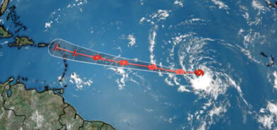
We are monitoring the development and movement of a tropical wave located over the Central Tropical Atlantic. This is causing rainfall of varying intensities, accompanied by disorganized thunderstorms. Forecasts indicate a 30% probability of cyclonic development over the next 48 hours, while for the next 7 days, an 80% probability. Due to its geographical position and movement, we are closely monitoring this weather system and recommend paying attention to our bulletins.
National District: After midday, cloud cover increases accompanied by local showers, isolated thunderstorms, and possible wind gusts, being more noticeable at night.
Santo Domingo Norte: this afternoon, cloud cover increases generating local showers, isolated thunderstorms and possible wind gusts until the beginning of the night.


Santo Domingo Este: this afternoon, cloud cover increases generating local showers, isolated thunderstorms and possible wind gusts until the beginning of the night.
Santo Domingo Oeste: Cloudy increases in the afternoon accompanied by local showers, isolated thunderstorms and possible wind gusts until the beginning of the night.
Temperatures: the minimum will be between 23 °C and 25 °C and the maximum between 33 °C and 35 °C.
Summary: During the morning hours, we will observe a sky with little cloud cover, mostly sunny. However, after midday we foresee the occurrence of scattered showers, thunderstorms, and wind gusts over different provinces of the northeast, southeast regions (including some municipalities of Greater Santo Domingo), the Central Mountain Range, the northwest and the border area, due to the humidity associated with the passage of a tropical wave with its greatest rainfall activity over the Caribbean Sea, in addition to the indirect incidence of an upper-level trough and the local effects, typical of the Dominican territory. For this reason, we maintain the alert levels and meteorological warnings in different provinces of the country.
On Wednesday, the humidity generated by the east/northeast wind, in addition to the approach of a new tropical wave and the incidence of a trough, will cause the weather conditions in our forecast area to become favorable for weak to moderate rainfall to occur from early hours of the day, being heavy at times with electrical storms and wind gusts over several provinces of the regions; northeast, the Caribbean coast, (including Greater Santo Domingo and the National District), the Central Mountain Range and the border area.
National District: After midday, cloud cover increases accompanied by local showers, isolated thunderstorms, and possible wind gusts until the beginning of the night.

Santo Domingo: mainly in the afternoon, cloudy increases accompanied by local showers, isolated thunderstorms and possible wind gusts until the beginning of the night.