
SANTO DOMINGO, RD. – The Emergency Operations Center (COE) Directorate reported this Sunday that hurricane Erin, currently category 3 on the Saffir-Simpson scale with sustained winds of 205 km/h, continues to generate indirect effects in the Dominican Republic, despite the fact that its center is approximately 320 km north/northwest of San Juan, Puerto Rico, and 280 km northeast of Punta Cana, moving west-northwest at 20 km/h and with a turn to the north expected for Monday or Tuesday.
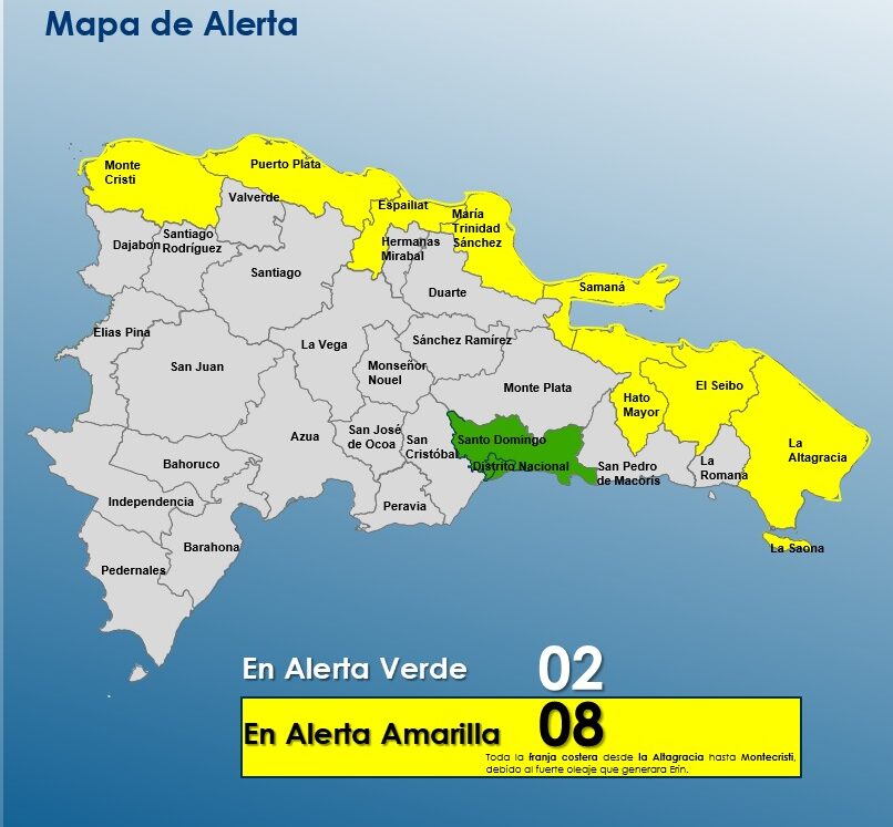
The agency warned that Erin’s interaction with the national territory will cause waves of up to 12 feet on the Atlantic coast, moderate to heavy showers, thunderstorms and wind gusts, especially in provinces under alert levels such as La Altagracia, La Romana, Monte Plata, San Pedro de Macorís, Hato Mayor, Santo Domingo, San Cristóbal, Peravia, Sánchez Ramírez, Monseñor Nouel, Santiago, Santiago Rodríguez, Duarte and Hermanas Mirabal.
You may be interested in: Emergency Operations Center (COE)

Under Law 147-02 on Risk Management, the COE maintains yellow alert for the entire coastal strip from La Altagracia to Montecristi due to strong waves, swell, breaking waves and rip currents, as well as green and yellow alerts for possible rises in rivers, streams and ravines and sudden or urban floods in several provinces and the National District. A
Furthermore, it was indicated that on the Atlantic coast, from Cabo Engaño to Montecristi and from Isla Saona to Cabo Engaño, all vessels must remain in port due to wind, abnormal waves, and reduced visibility, while on the Caribbean coast navigation is possible with caution.
More Read

Likewise, it prohibits the use of beaches and water sports on the Atlantic coast and warns the population not to approach the coast to observe the waves, due to the high risk this represents. The COE urges citizens to stay tuned to official bulletins, take extreme precautions and follow all safety recommendations in the face of the indirect effects of Hurricane Erin.