

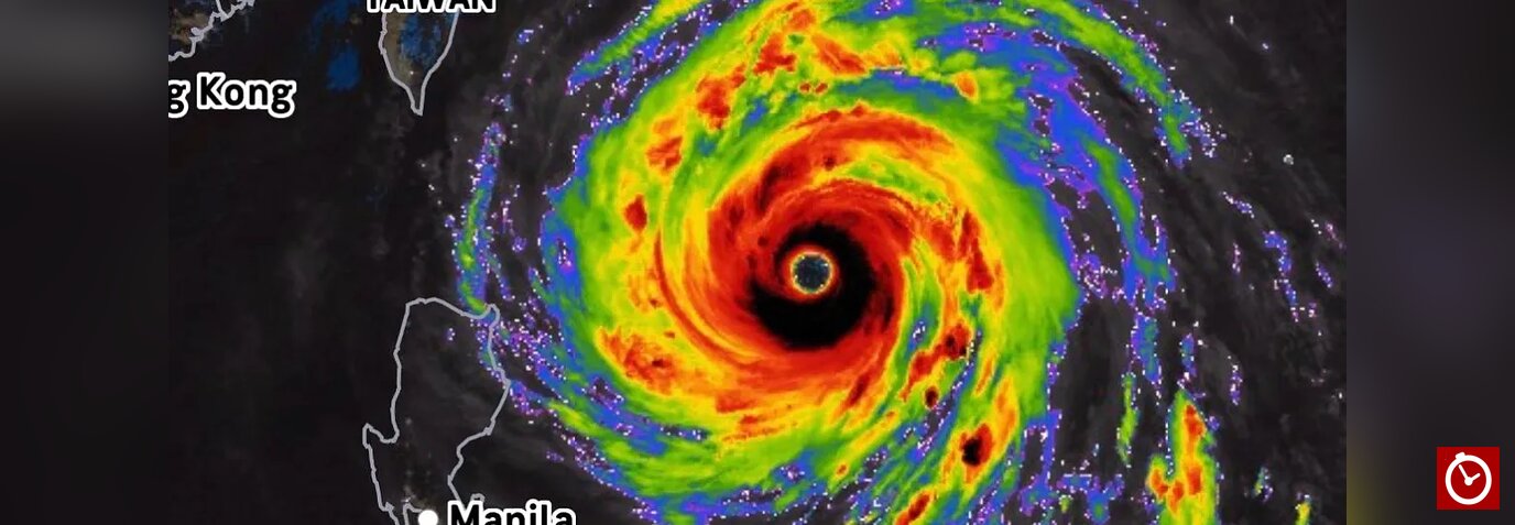

Super Typhoon Champi has intensified into a Category 5-equivalent storm, with maximum sustained winds reaching 185 mph (298 km/h), threatening parts of the western Pacific, including Okinawa and northern Taiwan.
According to FOX Weather, Champi’s wind speeds matched those of Sinlaku, making the two systems the most intense storms on Earth so far this year by sustained wind speed.
The U.S. National Weather Service office in Guam confirmed the storm’s strength in a report published Wednesday, October 21. At the time, Champi was located about 970 miles west-northwest of Guam and moving west-northwest at approximately 17 mph.
Champi’s passage near the Mariana Islands
On Sunday, October 18, the center of Champi passed about 10 miles from the southern tip of Guam. Although the storm avoided a direct hit on the island, it was officially classified as a super typhoon after its winds reached 150 mph (241 km/h), the threshold cited for that designation.

Much of Guam experienced tropical-storm conditions, with some gusts reaching typhoon strength. The system’s relatively fast forward movement and the rapid weakening of winds away from its center helped limit the duration of exposure to the strongest conditions.
Why did Champi become so powerful?
After moving away from the Mariana Islands, Champi underwent an eyewall replacement cycle, a process in which an outer ring of thunderstorms replaces the storm’s inner eyewall. This can temporarily weaken a cyclone before it reorganizes and potentially intensifies again.
After completing this phase, Champi strengthened further, reaching sustained winds of 185 mph.
Several environmental factors can contribute to rapid intensification:

- Warm ocean waters: Forecast analyses cited in the report indicated sea-surface temperatures of 82 to 84 degrees Fahrenheit (28 to 29 degrees Celsius), providing energy that can fuel a powerful tropical cyclone.
- Compact structure: Storms with small, well-defined eyes can develop extremely intense winds under favorable conditions.
- El Niño conditions: The article links the broader Pacific storm pattern to the development of a potential “super El Niño.” Such conditions can influence tropical cyclone formation and tracks, although they do not independently explain the intensity of an individual storm.
Climate change may also influence the intensity of tropical cyclones. Scientific evidence indicates that warming oceans can increase the proportion of storms reaching very high intensity and raise the potential for rapid intensification. This does not necessarily mean the total number of storms will increase.
Areas at risk as Champi moves northwest
Forecast projections described in the report show Champi curving northwest toward the region east of mainland Asia. Okinawa, the Ryukyu Islands and northern Taiwan were identified as areas potentially threatened toward the end of the week.
The storm was expected to gradually weaken as it approached southern Japan. However, even a weakening cyclone of this magnitude can produce dangerous winds, heavy rainfall and large waves.
Residents in potentially affected areas should follow official meteorological advisories as Champi’s track and intensity continue to evolve.