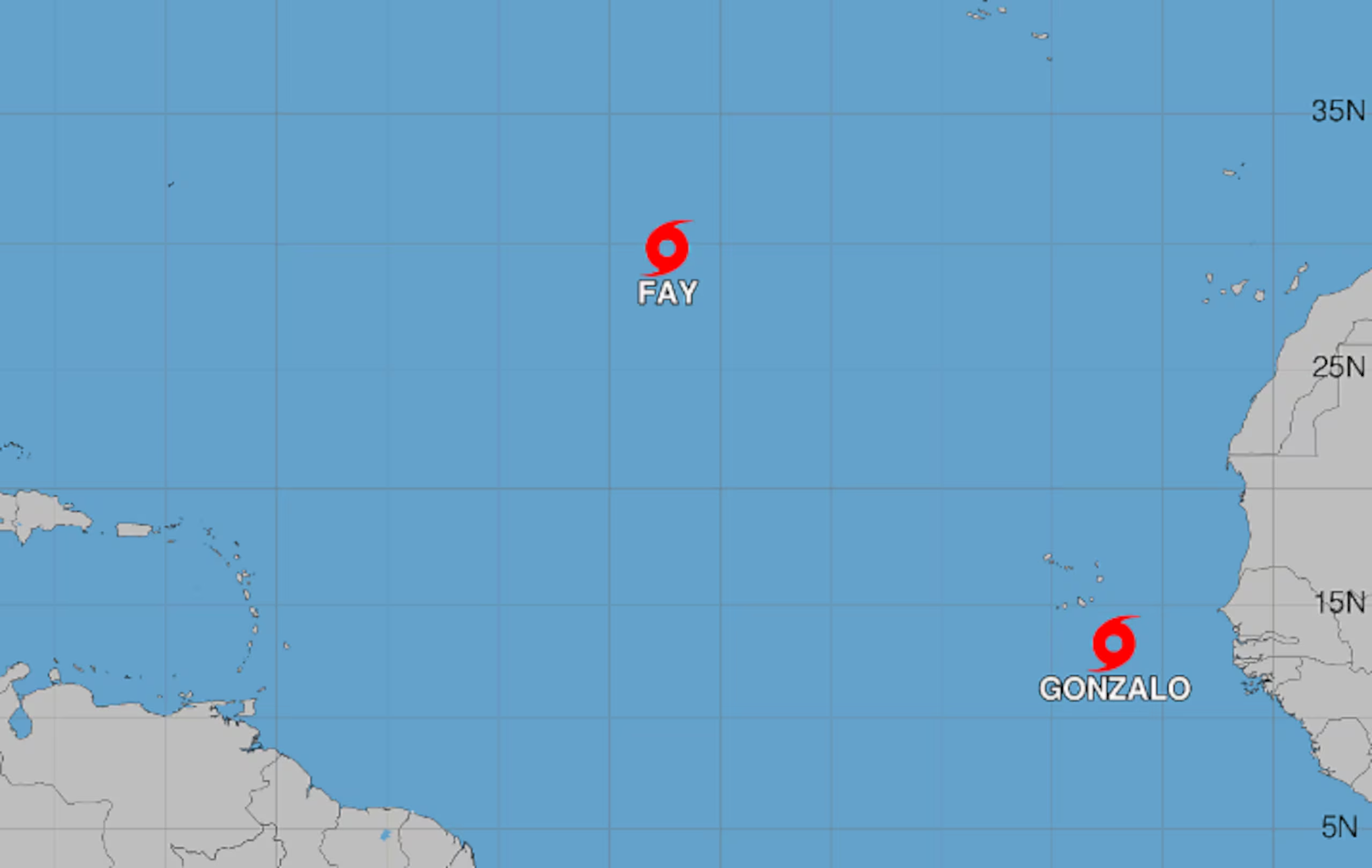
Miami (USA).- Tropical Storm Gonzalo, the seventh of the year in the Atlantic, formed this Friday near the African islands of Cape Verde, while Tropical Storm Fay continues to strengthen in the northern Atlantic Ocean, reported the United States National Hurricane Center (NHC).
Gonzalo formed during the early morning hours and, according to the latest bulletin from the NHC, it was located about 120 miles south of the Cape Verde Islands, with maximum sustained winds of 50 miles per hour.
You may be interested in: Samaná Governor leads delivery of food assistance to families affected by Storm Melissa in Sánchez
The weather system maintains its activity near the western coast of Africa and could generate significant rainfall in some areas over the next few hours. The NHC indicated that the rainfall associated with Gonzalo could affect Cape Verde and sectors of the West African coast between Guinea-Bissau and Senegal from this Friday through Saturday.
The U.S. agency warned of the possibility of flash flooding along the west coast of Africa, as well as some isolated flood risks in the eastern islands of Cape Verde.

Gonzalo’s Education
Gonzalo‘s formation occurs while Fay remains active in the Atlantic and presents favorable conditions for slight strengthening over the next few hours.
Fay was located in the last report about 1,065 miles west of the Azores islands, with maximum sustained winds of 50 miles per hour and moving westward. At the moment, the system does not pose a threat to land areas.
According to the NHC, Fay continues to produce areas of deep convection and maintains enough organization to favor possible strengthening. The agency noted that it could experience a slight increase in intensity over approximately the next 12 hours.
More Read

The evolution of Gonzalo and Fay is being followed by meteorologists as the Atlantic hurricane season maintains unusual activity for this time of year. So far, no hurricanes have formed in this basin, which represents a record low for the season.

Specialists attribute part of this behavior to the influence of the El Niño climate phenomenon, associated with higher-than-usual temperatures in the waters of the Pacific Ocean and changes in atmospheric patterns that can affect the formation and evolution of tropical cyclones.
In contrast to the Atlantic, cyclonic activity in the Pacific is higher. The NHC is keeping three hurricanes identified as Odalys, Polo, and Nolo under surveillance.
Hurricane Nolo could bring rain to the Big Island of Hawaii, while the other two systems remain far from land and, for the moment, do not pose a direct threat to populated areas.
The presence of Gonzalo in the Atlantic brings the number of tropical storms formed during the season in this basin to seven. However, the fact that a hurricane has not yet been recorded keeps the season below the usual levels for this period.
The National Oceanic and Atmospheric Administration (NOAA) lowered its forecasts for the Atlantic season on August 6 and estimated that up to 13 storms could form, a figure lower than the historical average.
More Read

For the eastern Pacific, however, NOAA maintains a forecast of up to 22 storms, above average, in a scenario marked by the strengthening of El Niño.
Meteorologists will continue to monitor the path and evolution of Gonzalo, as well as the atmospheric and oceanic conditions that may determine changes in its intensity.
For now, the main risks associated with Gonzalo are concentrated in rains and flooding in parts of Cape Verde and the West African coast, while authorities continue to monitor both tropical systems in the Atlantic.