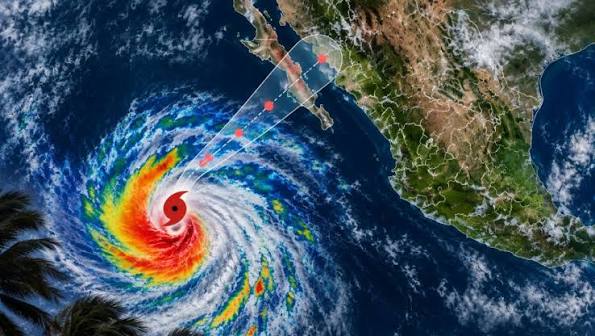
Mexico City.– Hurricane Polo reached category 5, the highest on the Saffir-Simpson scale, this Tuesday off the coast of the Mexican Pacific, after experiencing a rapid intensification that took it from category 1 to 5 in less than 24 hours, reported the National Meteorological Service (SMN).
At 06:00 local time, the center of the hurricane was located over the Pacific Ocean, about 355 kilometers south of Zihuatanejo, Guerrero, and 580 kilometers south-southeast of Manzanillo, Colima.
You might be interested in: Tropical depression in Mexico’s Pacific could become a hurricane, authorities say
The phenomenon presents maximum sustained winds of 260 kilometers per hour and gusts of up to 315 kilometers per hour, while it moves eastward at a speed of 9 kilometers per hour.
The intensification of the hurricane occurred rapidly over the last few hours. By Monday at noon, Polo was still a category 1 and was recording sustained winds of 130 kilometers per hour.
More Read

The SMN, which reports to the National Water Commission (Conagua), and the United States National Hurricane Center are maintaining a tropical storm watch zone from Tecpan de Galeana, in Guerrero, to Manzanillo, Colima.
Meteorological authorities warned that the hurricane‘s circulation will cause intense rains, with accumulations of between 75 and 150 millimeters, in Colima and areas of Michoacán, Guerrero, and Oaxaca.
Likewise, very heavy rainfall, between 50 and 75 millimeters, is forecast in the south, southwest, and coast of Jalisco, due to the effects associated with the system.
More Read

Hurricane
The passage of the hurricane will also be accompanied by strong wind gusts. On the coasts of Michoacán and Guerrero, they could reach between 60 and 80 kilometers per hour, while in Jalisco and Colima they could reach up to 60 kilometers per hour.

Another expected effect is an increase in swell. Authorities expect waves between three and four meters on the coasts of Michoacán and Guerrero, two to three meters in Colima and Oaxaca, and up to 2.5 meters in Jalisco.
The hurricane could generate dangerous conditions in coastal areas and increase the risk of landslides, especially in areas where accumulated rainfall is recorded. There is also a possibility of rising river and stream levels, overflowing, and flooding in low-lying areas.
Due to these conditions, Mexican authorities requested that the population remain attentive to the notices issued by the SMN and follow the recommendations of Civil Protection, especially in the areas under surveillance.
As a preventive measure against the arrival of the rains associated with the hurricane, the governments of Guerrero and Michoacán suspended classes on September 22 and 23.
The Federal Electricity Commission (CFE) also activated a preventive operation to respond to possible damage caused by the meteorological phenomenon. For these tasks, 1,320 electrical workers, 331 cranes, 445 light vehicles, and one communications vehicle were deployed.
More Read

The response device also includes 82 emergency power plants, 68 lighting towers, and a helicopter, resources intended to address potential damage to electrical infrastructure and restore service in the event of interruptions.
The evolution of Hurricane Polo will continue to be monitored by Mexican and American meteorological authorities, due to its intensity and the effects it may generate on different states of the Mexican Pacific.
The authorities reiterated the call to avoid risk areas, stay informed through official channels, and follow the instructions of emergency agencies while the influence of the hurricane continues.
Guterres also raised the need to establish independent oversight mechanisms to ensure that the development of artificial intelligence systems advances under criteria of responsibility, transparency, and accountability, especially given the growing impact of this technology in different areas of society.